|
Dells of the Wisconsin River State Natural Area This property is 1,300 acres in size and protects some of the most pristine areas of the Dells of the Wisconsin River in parts of Adams, Columbia, Juneau and Sauk Counties. The birding opportunities are great along a spectacular gorge, cliffs, tributary canyons, and unusual rock formations carved by the catastrophic drainage of glacial Lake Wisconsin some 12,000 years ago. The sandy uplands are wooded with both hardwood and pine species, including hemlock, red oak and white pine. This forest diversity draws in many different species of birds. Many unusual plants grow here including tiny asters, ferns, and sedges. 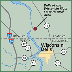
Directions: From Wisconsin Dells, go east 0.6 miles on Hwy 13, then north 1.7 miles on River Road to a parking area west of the road. A hiking trail leads to the river. Another parking area is located 1.9 miles farther north along River Road. The rock formations are best seen by water. A boat landing is located on River Road, 0.5 mile north of Hwy 13. The cliffs and side canyons are closed to the public to protect sensitive features. Gazetteer: Page 43, C-5 (prior to 10th edition). | Page 77, D-5 (10th edition). Phone: 608/339-3385 (Friendship DNR). Web site: WDNR Dells of the Wisconsin River State Natural Area Signature Species: Northern Rough-winged Swallow, Bank Swallow, Cliff Swallow and Barn Swallow. Rare Species: Yellow Warbler, Prothonotary Warbler and Northern Waterthursh. Parking: Parking areas. Nearest food & lodging: Wisconsin Dells. |
