|
Quincy Bluff and Wetlands State Natural Area Quincy Bluff and Wetlands is a 5,102 acre, landscape-scale natural area in the flat, sandy bed of former Glacial Lake Wisconsin. Quincy Bluff and Rattlesnake Mound are both sandstone mesas that border this vast wetland complex of sedge meadow, tamarack swamp, shrub-carr and small ponds. Low sandy ridges support barrens communities of jack pine and Hill’s oak. Quincy Bluff looms 200 feet above the wetland and is forested with oak and pine. Small forest openings support prairie plants and draw in some interesting grassland sparrows. Overhead, Turkey Vultures and Bald Eagles soar on warm currents of air, while Red-tailed Hawks perch on tree limbs along woodland edges. Directions: From the intersection of Hwy 13 and Cty H east of White Creek, go west 2.4 miles on Cty H, then north 0.4 miles on 16th Ave, then west 0.5 miles on Evergreen Ave, then north 2.4 miles on 16th Drive to a parking area east of the road. 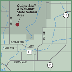
Gazetteer: Page 43, B-5 (prior to 10th edition). | Page 76, B-4 (10th edition). Phone: 608/339-3385 (Friendship DNR). Web site: WDNR Quincy Bluff and Wetlands State Natural Area Signature species: Willow Flycatcher, Great Blue Heron and Common Raven. Rare species: Blue-headed Vireo,
Red-headed Woodpecker, Gray
Jay and Golden-crowned Kinglet. Nearest food & lodging: Friendship. |
