|
Pine Island State Wildlife Area This 5,165-acre property lies in the floodplain of the Wisconsin and Baraboo Rivers. It includes several islands in the Wisconsin River and was named for one of those larger islands that had a significant stand of white pine. A levee was constructed on the south and north side of the Wisconsin River for flood control to protect the City of Portage and farmlands along the river. Today, the area includes marsh, shrub swamp, floodplain forest, savanna, restored prairie grasslands and barrens. The grasslands found here are home to many species grassland birds and the property is part of the Leopold- Pine Island Important Bird Area. Directions: From Portage, take Hwy 33 south. Just across the river, turn west on Blackhawk/Levee Rd 0.5 mile. Levee Rd runs through the SWA for the next 6 miles. 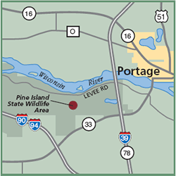
Gazetteer: Page 43, D-7 (prior to 10th edition). | Page 77, E-7 (10th edition). Phone: 608/266-2621 (Madison WDNR). Web site: WDNR Pine Island State Wildlife Area Signature Species: Orchard Oriole, Barred Owl and American Woodcock. Rare species: Henslow’s Sparrow, Grasshopper Sparrow and Eastern Meadowlark. Parking: Parking lots. Nearest food & lodging: Portage and Baraboo. |
