|
Observatory Hill State Natural Area Observatory Hill is the highest point in Marquette County, rising 300 feet above the countryside. It was a favorite childhood haunt of naturalist John Muir who lived nearby. A trail leads to the top where you can immerse yourself in the beauty of this Central Wisconsin landscape. The woods that cover the property are being restored to oak savanna. It contains remnant prairie plants. The mix of oaks, basswoods and cedar trees attract many species of songbirds including Scarlet Tanagers, Cedar Waxwings, Red-eyed vireos, and Golden-crowned Kinglets. 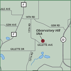
Directions: From Montello, go south 4.8 miles on Cty F, then east 0.5 mile on 14th Road, then south 1.4 miles on 13th Road, then east 0.6 mile on Gillette Drive to a parking area north of the road. A footpath to the summit begins in the northwest corner of the old field. Gazetteer: Page 44, C-1 (prior to 10th edition). | Page 77, D-8 (10th edition). Phone: 920/787-4686 (Wautoma WDNR). Web site: WDNR Observatory Hill State Natural Area Signature species: Turkey Vulture, Bald Eagle and Eastern Phoebe. Rare species: Loggerhead Shrike, Warbling Vireo and Redheaded Woodpecker. Parking: Parking lot. Nearest food & lodging: Endeavor or Montello. |
