|
Moquah Barrens Wildlife Area The area is a former barrens that is now forested. The vegetation is a mix of open, upland jack pine barrens, red pine savanna, and mixed pine/oak forest. There are several sandy-bottomed lakes at the southwest edge of the area. The area, well known for its blueberries, is managed with prescribed fire, and has a superb late summer wildflower bloom. Directions: This 5,000-acre refuge is located 16 miles west of Ashland in the Chequamegon-Nicolet National Forest. From Ashland, travel 13 miles west on Hwy 2 to the junction of Forest Road 236 in the small town of Ino. Turn right (north) on FR 236 and travel about 5 miles north to the junction of FR 242. This is the southeast corner of the wildlife area. Another mile north on FR 236 brings you to the south edge of the Moquah Natural Area, the nation’s first Research Natural Area (marked with a sign). Numerous roads through the barrens, can be traveled by car. Gazetteer: Page 102, D-3 (prior to 10th edition). | Page 22, F-2 (10th edition). 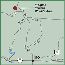
Notes: The site has a wolf pack and black bears. Phone: 715/373-2667 (US Forest Service). Website: Chequamegon-Nicolet National Forest Signature Species: Sharp-tailed Grouse (the spring dancing season is tops). Rarities: The site is well known for its open grassland bird species. Hours: 24/7. Nearest food & lodging: In Iron River, 5 miles southwest. The Forest Service operates 3 area campgrounds: Wanoka Lake (5 miles), Birch Grove (7 miles) and walk-in only Bladder Lake (1 mile). |
