|
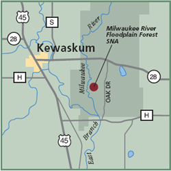
Milwaukee River Floodplain Forest State Natural Area This 119-acre property is located along the East Branch of the Milwaukee River. It features a bottomland hardwood forest with small upland islands in the river. The site also contains dry-mesic forest and shrubcarr. Large silver maple and green ash with hackberry dominate the well-structured floodplain forest with black ash and bur oak trees. The ground layer plants include bedstraw, sensitive fern, water parsnip and green dragon. Shrubs include dogwoods, prickly ash and hawthorn. This is a good place to walk in the early morning to look for Indigo Buntings, Song Sparrows, Common Yellowthroats and Catbirds. Directions: Located within the
Northern Unit of the Kettle Moraine
State Forest. From Kewaskum go east 2
miles on Hwy 28, the south 1.2 miles
on Oak Drive Rd. The site lies .1 mile
west of the road. Gazetteer: Page 46, D-3 (prior to 10th edition). | Page 80, F-1 (10th edition). Phone: 414/263-8500 (WDNR Southeast Region Headquarters). Web site: WDNR Milwaukee River Floodplain Forest State Natural Area Signature species: Blue-Gray Gnatcatcher, Barred Owl and Great-horned Owl. Rare species: Brown Creeper and longear sunfish. Parking: Parking area. Nearest food & lodging: Kewaskum. |