|
Machickanee Unit – Oconto County Forest The Machickanee Forest is a 3,100-acre unit of the Oconto County Forest. Located just east of Oconto, the forest is bisected by a 2,200-acre bulge in the Oconto River called the Machickanee Flowage. The forest is a site for birders and hikers, while the flowage is popular with anglers, particularly in winter. There are miles of hiking trails that access the property. Bring a canoe or kayak to see the herons, bitterns and numerous species of waterfowl along the river and flowage. In the forests, see Veerys, Red-breasted Nuthatches, Golden-winged Warblers, and Scarlet Tanagers. Directions: North of the river, drive east on Cty I (Stiles Rd); south of the river use Konitzer Rd and Timberline Rd. 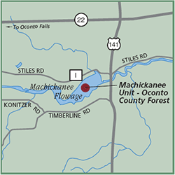
Gazetteer: Page 67, B-8 (prior to 10th edition). | Page 61, B-6 (10th edition). Phone: 920/834-6827. Signature Species: Red-shouldered Hawk, Blackburnian Warbler, and Ruby-crown Kinglet. Rare Species: Yellow-throated Warbler, Swainson’s Thrush, and Hooded Warbler. Seasonality: Open all year. Parking: Parking lots. Nearest food & lodging: Oconto Falls. |
