Lower Wisconsin State Riverway – Helena Unit The Lower Wisconsin State Riverway flows unimpeded 92.3 miles from below the dam at Prairie du Sac to its confluence with the Mississippi River near Prairie du Chien. It encompasses 40,000 acres of DNR land on both sides of the river. It was created in 1989 to protect and preserve the scenic beauty and natural character of the river valley, and to manage the resources of the area for the long-term benefit of the citizens of the state. The LWSR is divided into 26 management units; the Helena Unit centers on Spring Green. There are 285 bird and 45 mammal species found within the riverway. Directions: From Spring Green, travel south on Hwy 23 or Hwy 14 to access the Helena Unit. Consult your Gazetteer for additional access along the river from Prairie Du Sac to the Mississippi River. 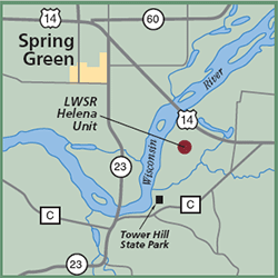
Gazetteer: Page 34, C-3 (prior to 10th edition). | Page 84, D-3 (10th edition). Phone: 608/739-3188 or 800/221-3792 (both Lower Wisconsin State Riverway Board). Web site: WDNR Helena Marsh Unit | Lower Wisconsin State Riverway Board Signature Species: Bald Eagle, Osprey, Common Merganser and Common Goldeneye. Rare Species: Golden Eagle, Cerulean Warbler, Kentucky Warbler, and Yellow-breasted Chat. Parking: Parking lots. Nearest Food & Lodging: Spring Green. |
