|
Chippewa River State Trail The Chippewa River State Trail is a 26.5-mile railbed trail that meanders with the river from Durand to Eau Claire. Gray Catbirds, Indigo Buntings and Red-shouldered Hawks are easy to spot along this trail. Several bridges along the way make for an interesting hike and are great to photograph. Along the way, the Red Cedar and Chippewa Rivers meet about seven miles northeast of Durand. From that junction, the Red Cedar State Trail runs north 14 miles to Menomonie. The Red Cedar River valley glides through steep rock walls and lush forests. Belted- Kingfishers dive from lofty perches to feed on small fish along the river and the songs of Scarlet Tanagers, Eastern Wood-Pewee and Whip-poor-wills can be heard along the way. Directions: Trailheads can be found in Durand and Eau Claire. 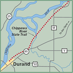
Gazetteer: Page 60, C-1 (prior to 10th edition). | Page 54, C-4 (10th edition). Phone: 715/232-1242. Web site: Chippewa River Trail Signature Species: Eastern Kingbird, Belted Kingfisher and Willow Flycatcher. Seasonality: Open all year. Parking: Parking lots provided. Nearest food & lodging: Durand, Menomonie and Eau Claire. Fee: A trail pass is required for all uses except hiking. |
