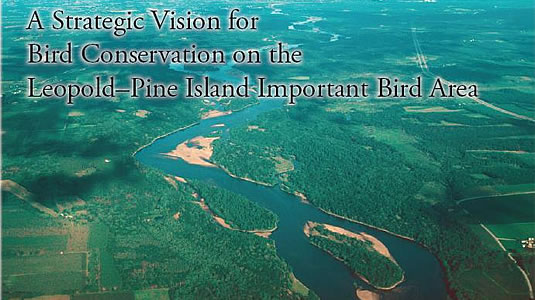
Project Description
This IBA has been the flagship project in the development and implementation of our strategic conservation process. Four key features, or milestones, in the process stand out in the story of this project: Research; Partnership; Perspective; and Strategic Action.
Research: The seeds of this project were planted in 2004 when several local landowners, biologists, and advocates proposed expanding the boundary of an existing IBA nomination for Pine Island State Wildlife Area to encompass additional high-quality habitats on adjacent public and private lands. The lack of bird data on these parcels, necessary to evaluate them against IBA criteria, led to the development of a bird survey in which a system of points and transects was established across the entire proposed IBA and inventoried for breeding and migrating birds. The survey was designed to serve as a basis for long-term monitoring as well as for collecting information on bird-habitat relationships. Volunteers collected additional data on migrants and breeders through area searches and Breeding Bird Atlas-style observations. The data from these survey efforts led to the site being approved as an IBA in late 2005.
Leopold-Pine Island Points-and-transects map & Properties map (PDF)
Partnership: A dedication ceremony in the fall of 2007 gathered all the various partners in this diverse IBA together and generated a lot of excitement about next steps and how an active partnership could add value to each individual stakeholder. A core leadership team emerged at this time that was instrumental in developing project ideas, coordinating work and resources, reaching out to partners, and driving the project forward: Steve Swenson, ecologist with the Aldo Leopold Foundation; Mike Mossman, ecologist with WDNR; and Yoyi Steele, IBA Coordinator for WBCI.
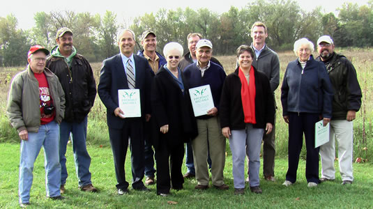
Leopold-Pine Island IBA Dedication. From left to right: Frank Terbilcox, private landowner; Jeff Nania, Wisconsin Waterfowl Association; Matt Frank, WDNR Secretary; Greg Kidd, NRCS; Joan Pines, private landowner and host; Jim Lutes, USFWS; Phill Pines, private landowner and host; Yoyi Steele, IBA Coordinator; Kevin McAleese, Sand County Foundation; Nina Leopold Bradley; and Buddy Huffaker, Aldo Leopold Foundation
After a series of partner meetings, discussions, data analysis, and GIS work, we developed a detailed report summarizing the results of the bird survey and laying out a vision for managing the IBA as a landscape while respecting the property goals of individual landowners and land managers.
Perspective: In this report, the comprehensive IBA-wide bird survey was our foundation for strategically identifying priority species, exploring bird-habitat relationships, determining relative opportunity for different species and habitats, and recommending how each property can contribute to the larger whole. We completed this report in 2009 and presented it to the IBA partnership, where it was very well received. This effort was instrumental in helping each partner gain valuable perspective: understanding what the IBA can do “best” conservation-wise, and how their individual property fits in to the IBA and the larger landscape.
We met with each partner individually to discuss management on their property in more detail and how the goals of the larger IBA could be integrated with their own property goals. Based on these conversations we delineated tentative management units on each property and proposed more specific management recommendations for them that follow from the ‘big picture’ laid out in the Strategic Vision report. We also proposed IBA-wide population objectives for a subset of priority species and, where appropriate, stepped these objectives down to individual properties. This Detailed Stewardship Recommendations document, with accompanying management unit maps of each property, was completed in early 2010 and presented to the larger partnership and to partners individually.
Strategic Action: The partnership has now entered the ‘implementation’ phase of the strategic process, carrying out management based on our collaborative planning; evaluating its effects; and using existing and new monitoring efforts to determine whether management is having the desired effects on birds and their habitats.
Next Steps
For 2010 and beyond, the Leopold-Pine Island partnership is embarking on the following:
- Actively seeking funding for management activities through state and federal grants.
-
- Establishing new monitoring programs. These programs have a two-fold purpose: to generate supplemental data and fill data gaps for species that are not well monitored using traditional techniques like point counts; and to encourage local participation and ownership in the IBA by recruiting and training volunteers to conduct monitoring. We received a Citizen-based Monitoring Partnership Program grant in 2010 to help develop this effort. The new programs include:
- Marshbird monitoring.
- American Woodcock nocturnal roadside survey routes.
- Red-shouldered Hawk survey routes.
- Nocturnal roadside survey routes for frogs, toads, and nocturnal birds (owls, whip-poor-wills).
- Daytime roadside survey routes modeled after the Federal Breeding Bird Survey.
- A web-based system for volunteers to report anecdotal and targeted bird observations.
- Establishing new monitoring programs. These programs have a two-fold purpose: to generate supplemental data and fill data gaps for species that are not well monitored using traditional techniques like point counts; and to encourage local participation and ownership in the IBA by recruiting and training volunteers to conduct monitoring. We received a Citizen-based Monitoring Partnership Program grant in 2010 to help develop this effort. The new programs include:
These surveys all employ the same protocols as similar monitoring programs being conducted statewide, regionally, and nationally, giving us the ability to compare our IBA data to larger-scale trends.
- IBA-wide survey. We plan to repeat the IBA-wide bird survey in 2011, using the established point-and-transect system and volunteer observations.
- Vegetation mapping project. Although the IBA-wide survey collects data on bird habitat use, the bird data set is much more useful if we can document the type, quantity and distribution of the many plant communities that occur on the IBA. Next year, in the same year as the bird re-survey, we will create a vegetation map of the entire IBA that will quantify breeding bird habitats. This project will allow us to relate our bird population estimates to available habitat, giving us a foundation for translating bird population goals into habitat objectives (e.g., “to support 200 pairs of Henslow’s sparrow we will need to manage so many acres of tall, thick grassland habitat”). This effort will also establish benchmarks by which the effectiveness of land management decisions can be better understood. The mapping will follow the vegetation classification systems of both the Wisconsin Breeding Bird Atlas and the Natural Heritage Inventory.
These efforts will continue to add value to partners, strengthen collaborations, and help the partnership evaluate the success of its work and adapt. As stated in the Detailed Stewardship Recommendations:
“We expect that the priorities and recommendations described in this report will be modified as the IBA’s community of partners continues managing the land, evaluating the results, considering new information and opportunities, and working to mesh objectives of the varied programs and principles that guide management on individual tracts. Regardless of these inevitable changes, we hope that this community nurtures and actively pursues its commitment to “a whole that is greater than the sum of its parts”, and by doing so, helps the LPI IBA realize its full conservation potential.”
Partners
- Aldo Leopold Foundation
- Sand County Foundation
- WDNR, Pine Island Wildlife Area
- USFWS, Leopold Wetland Management District
- Natural Resources Conservation Service
- Private landowners, including Phill and Joan Pines, Frank and Colleen Terbilcox, and others. Neighbors to the IBA are welcome and encouraged to participate in the IBA, and learn about the significance of their land for birds.